REVIEW · HELICOPTER TOURS
30 Minutes SHARED Helicopter Tour in Honolulu
Book on Viator →Operated by Honolulu Helicopter Tours · Bookable on Viator
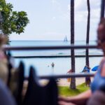
Thirty minutes of Oahu from above changes everything. This shared helicopter loop over Oahu is built for big views in a short time, with pilot commentary that helps you recognize what you’re looking at from the sky.
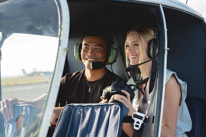
What I like is how it stays personal: the aircraft is kept to a maximum of three travelers, so your pilot can actually point things out instead of racing through a script. I also like the photo potential—this route passes over landmarks like Ala Moana Beach Park and Diamond Head without asking you to hike, park, or wait.
One consideration: it’s a flyover, not a long on-the-ground experience. At $319 per person for about 30 minutes, it’s best if you’re excited by aerial sightseeing and not by stopping to explore.
In This Review
- Key highlights worth getting excited about
- A 30-minute Honolulu helicopter hop: why it works
- Meeting point at 1 Lagoon Dr and what to plan for
- The flyover route: where you’ll look first
- Starting at HNL: Sand Island and the harbor edge
- Ala Moana Beach Park and Magic Island: beach geometry from the air
- Ala Wai Harbor and Waikiki: hotels, coastline, and the “where am I?” moment
- Diamond Head and Waialae Country Club: geology and golf-course layout
- Downtown Honolulu and the Punchbowl Crater: the city gets meaning
- Moanalua Freeway interchanges, H-3, and Aloha Stadium: Oahu’s infrastructure story
- Black Point Sea Pools and Moanalua Gardens: the quieter side of the island
- Photo strategy: how to get strong shots without making it stressful
- Price and value: $319 for 30 minutes, and how it can make sense
- Who should book this shared Honolulu helicopter tour?
- Flight-day comfort and expectations (headsets, weight, and good weather)
- Should you book this 30-minute Honolulu helicopter tour?
- FAQ
- How long is the shared helicopter tour?
- Where do I meet, and where does the tour end?
- What is the maximum group size?
- Is there a weight limit?
- What’s included with the tour?
- What happens if weather is poor, or I need to cancel?
Key highlights worth getting excited about
- Small-group feel (max 3 passengers) means more time hearing the pilot explain what you see
- A tight 30-minute route packs Waikiki, Diamond Head, Honolulu Harbor, and Punchbowl Crater into one flight
- Headsets + cell phone lanyard make it easier to hear the commentary and keep your phone secure while shooting
- Pilot names you may hear in the operation include Scott, Stefan, and Jacob, with pilots described as friendly and thorough
- Photo-minded options like doors-off flying are mentioned as a great way to capture sharper images when it’s offered
- Good-weather requirement keeps the experience more dependable, but it can shift dates if conditions are poor
A 30-minute Honolulu helicopter hop: why it works
A lot of Oahu sightseeing is either time-consuming (traffic, lines, parking) or spread out (you drive around the island and hope for clear timing). This helicopter format flips that. You get a concentrated aerial loop that shows the island’s shape fast—coastline, harbors, highways, and major neighborhoods—so you can understand where everything sits in relation to everything else.
The time matters. Thirty minutes sounds short until you’re actually up there, because you’re not doing check-in tasks or waiting between stops. You’re just flying, looking, and listening. With pilot commentary in English, you’re not stuck guessing what the coastline or crater formation is.
Also, the small size keeps it from feeling like a cattle ride. Even as a shared tour, it caps at three people, which makes the whole thing feel closer to a customized route than a mass-production sightseeing flight.
You can also read our reviews of more tours and experiences in Oahu


Meeting point at 1 Lagoon Dr and what to plan for

Your tour starts and ends back at the meeting area at 1 Lagoon Dr, Honolulu, HI 96819. The start is at HNL, and the experience returns to the same meeting point, so you don’t need to figure out a new location after you land. It’s also listed as near public transportation, which is a helpful detail if you’re trying to avoid rental-car logistics.
Because this is weather-dependent, I’d treat this like a half-day commitment in spirit, even though the flight itself is only about 30 minutes. Plan for the idea that timing may shift to protect flight safety when conditions aren’t right.
Bring what you need for quick photos, but keep it simple. You’ll be provided an aviation headset, and you’ll also have a cell phone lanyard, which is exactly the kind of small item you’re glad exists when you’re trying to film or photograph without sweating every movement.
The flyover route: where you’ll look first
This loop gives you a full “best-of” view, but in a smart order: airport area and coastline, then harbors and beaches, then the dramatic volcanic landmark, then inland and freeway geography, and finally stadium and seaside structures. The best way to enjoy it is to decide in advance what you want most—Waikiki angles, Diamond Head views, or the older/industrial look of the harbor and sea pools—and then stay flexible when the pilot calls your attention to something new.
You’re not landing at any stop. Instead, you’re scanning from above while the pilot narrates what you’re seeing and where you are relative to the island.
A shared flight can mean you’re sharing attention, too. Still, the pilot’s job is to keep everyone oriented, and with only up to three people on board, it’s easier to get that clear “Oh, that’s what that is” feeling.
Starting at HNL: Sand Island and the harbor edge
The tour begins at HNL (Honolulu), and the first key aerial sight is Sand Island. From above, this area helps you place the airport and the shoreline. It’s the kind of land-and-water junction that looks busy even when you’re not thinking about it—ports, channels, and coast shape show up instantly from the sky.
Then you move into views of Honolulu Harbor, also associated with traditional names like Kulolia and Ke Awa O Kou, plus the Port of Honolulu. This part is valuable because it shows you the island’s working side. From street level you see parts of the waterfront; from the helicopter you understand the bigger layout—where the sea lanes meet the city, and how the harbor sits against the neighborhoods.
Photo note: harbor light can change fast depending on cloud cover and sun angle. Keep your phone ready, but listen first. When the pilot points out a feature—channel line, breakwater, or a specific pier area—you’ll know exactly what you’re aiming for.
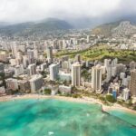
Ala Moana Beach Park and Magic Island: beach geometry from the air
Next up is Ala Moana Beach Park, a major public park between Waikiki and downtown Honolulu. From above, the big value is scale. It’s listed as a 100-acre park with a wide gold-sand beach over half a mile long, and aerial views make that length obvious in a way walking around never will. You’ll likely spot how the beach wraps around the coastline and how it relates to nearby hotels and waterways.
Adjacent is Magic Island, a small man-made peninsula by Ala Moana Beach Park and the Ala Wai Yacht Harbor. This is one of those places where the real story is hard to feel from the ground. Up in the air, you can see that it’s intentionally shaped, and you can connect it visually to the harbor and shoreline.
A quick tip: if you care about beach photos, aim for the moment the helicopter is giving a clean, steady view—don’t rush. The best shots are often the ones you take while your frame is stable, not while you’re scrambling to find the subject.


Ala Wai Harbor and Waikiki: hotels, coastline, and the “where am I?” moment
Your route continues over Ala Wai Harbor, described as the largest small boat and yacht harbor in Hawaii. From above, it reads like a neat grid of marinas meeting the ocean. You can also see how it lines up between Waikiki and downtown Honolulu, with Magic Island nearby.
Then you hit Waikiki, where high-rise hotels line the shore and Kalakaua Avenue anchors a major shopping corridor. You may also spot landmarks that sit behind the hotel row, like the area near Honolulu Zoo and the Waikiki Aquarium reef exhibit—up in the air, those locations become reference points rather than distant ideas.
This stretch is one of the best value parts of the loop because it gives you the island’s “front page” in one glance: beach, hotels, and shoreline edges all in the same frame. If you’re arriving in Honolulu for the first time, this is the moment where things click—where your hotel likely sits relative to Diamond Head and the harbor.
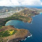
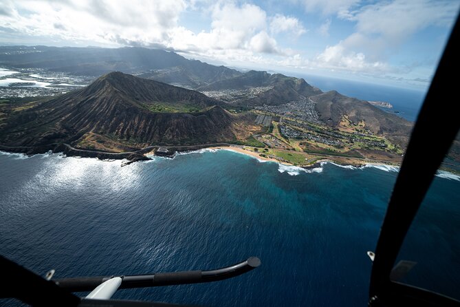
Diamond Head and Waialae Country Club: geology and golf-course layout
No Oahu aerial experience feels complete without Diamond Head, known to Hawaiians as Lēʻahi. From above, it’s easy to appreciate why the ridgeline shape is compared to the dorsal fin of a tuna. You’re seeing the volcanic cone form and the way the crater edges sit against the city grid.
Then you glide over Waialae Golf Course area, including Waialae Country Club, a private course founded in 1927 and designed by Seth Raynor. Even if you’re not a golfer, the aerial view helps you understand how large, landscaped spaces carve out the broader urban coast picture.
Consideration here: if you’re hoping for a long stare at Diamond Head, remember the flight is about 30 minutes total. The trick is enjoying the quick clarity. Up above, you can learn far more about spatial relationships than you can from a single street viewpoint, even if you only get a few minutes on each landmark.
Downtown Honolulu and the Punchbowl Crater: the city gets meaning
Next comes Honolulu downtown, the political and business hub with skyscrapers and Iolani Palace, plus the Hawaii State Art Museum. From the air, downtown reads as both a cluster and a set of angles: the street grid, the harbor edge, and the way development spreads toward the water.
Also in view is the Aloha Tower Marketplace area on Honolulu Harbor, with sea views from the historic 1920s Aloha Tower. From above, that tower area works like a visual anchor—one of those spots that lets you orient yourself quickly.
Then your route includes Punch Bowl Crater, where the National Memorial Cemetery of the Pacific sits. This part is heavier in tone than most sightseeing. From above, the crater shape does the talking first: you can see the bowl formation, then the memorial setting makes sense as part of the land itself. It’s a reminder that Oahu is not just scenery—it’s lived-in places with real meaning.
Moanalua Freeway interchanges, H-3, and Aloha Stadium: Oahu’s infrastructure story
After the major city and coastal landmarks, the flight shifts toward the island’s middle and highway geography.
You’ll pass by the Moanalua Freeway section designated as Route 78 between Route 99 (Kamehameha Highway) and the western H-1 interchange. You’ll also see Interstate H-3, known as the John A. Burns Freeway, including viaducts and tunnels such as the Tetsuo Harano Tunnels (listed as 5,165 feet). Even though you’re not driving it, the overhead view helps you understand how Oahu’s terrain forces creative engineering.
Later, your route includes Aloha Stadium, described as a closed multi-purpose stadium in Halawa and noted as Hawaii’s largest stadium. If events aren’t running, the aerial view still gives you a clean read on location—big stadium shape, surrounding roads, and the way Halawa connects to the rest of the island.
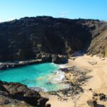
Black Point Sea Pools and Moanalua Gardens: the quieter side of the island
Your route also includes Black Point Sea pools, which is exactly the sort of coastal feature that can be hard to “get” from the ground unless you’re already nearby. From above, it’s easier to recognize where ocean access meets rock structures, and you can connect the coastline patterns without needing to walk them.
Then comes Moanalua Gardens, a 24-acre privately owned public park. You’ll fly over the area tied to Kamehameha V Cottage, the Prince Lot Hula Festival location, and a famous monkeypod tree known in Japan as the Hitachi tree. From the helicopter, the gardens read like a defined green pocket in a city setting, which helps you see the island’s mix: dense neighborhoods next to protected spaces.
It’s a good balance. The route doesn’t just repeat the most photographed coastline. It gives you at least a couple of angles that feel more like “how the island actually fits together.”
Photo strategy: how to get strong shots without making it stressful
You’re going to be tempted to shoot constantly. Try a different approach: pick your top three moments and treat everything else as bonus.
Here’s what I’d prioritize on this route:
- Waikiki shoreline + hotel line for an easy-to-recognize postcard frame
- Diamond Head crater edges for a dramatic subject that actually looks different from the sky
- Honolulu Harbor to show Oahu’s working coastline, not just beach scenery
With the included headset, you can also better time your camera. When the pilot talks about what you’re seeing, that’s your cue to slow down and frame carefully.
Doors-off flying is mentioned as an upgrade in the experience notes people share. If doors-off is offered on your flight day and weather permits it, it can improve your photo angle and reduce windshield-style reflections. Just remember your safety guidance and let the crew decide what’s possible.
Price and value: $319 for 30 minutes, and how it can make sense
At $319 per person for about 30 minutes, this is not a “cheap thrill.” The value comes from three things working together:
- You’re paying for speed plus perspective—a short time that covers a lot of geography
- You’re paying for a small group (max three people), which changes how the pilot can interact
- You’re paying for the full loop from harbor to beaches to volcano to crater and inland highways, without transit stress
If you can split the total with a small group, the experience notes mention group discounts, which can help the math. Also, the tour is typically booked about 32 days in advance on average, so planning ahead usually helps you line up a flight that matches your trip timing.
Bottom line: I’d book this if you want a single, high-impact highlight. If you want hours of walking and stopping, this isn’t that. It’s an aerial snapshot with real context.
Who should book this shared Honolulu helicopter tour?
This tour fits best when you:
- Want a first-time Oahu aerial overview that helps you understand where Waikiki, Diamond Head, and the harbor sit
- Prefer a short commitment instead of an all-day excursion
- Enjoy photo opportunities and want to see major landmarks from a fresh angle
- Travel as a small group and like the idea of a max-three layout
It may be less ideal if you:
- Hate the idea of a flight where weather could shift timing
- Expect ground stops or long explanations on the ground
- Are hoping for an extended duration to chase multiple lighting changes
One more practical detail: there’s a weight limit listed at 300 lbs per passenger. If you’re near that limit, confirm details at booking so there are no surprises.
Flight-day comfort and expectations (headsets, weight, and good weather)
The experience includes aviation headsets, which makes it much easier to hear the pilot commentary and stay comfortable during the flight. You’ll also get a cell phone lanyard, a small but smart inclusion for filming or photographing without playing phone-grab roulette.
This tour requires good weather, so don’t plan something critical immediately after the flight. If conditions aren’t right, the operator offers either a different date or a full refund, depending on the situation.
Finally, confirmation is received at booking, and the tour is offered in English. If you’re bringing friends or family who want clear narration, that’s a genuine advantage.
Should you book this 30-minute Honolulu helicopter tour?
I’d book it if you want one trip highlight that gives you Oahu’s layout in minutes. The small group size, pilot-led context, and the tight route over Waikiki, Diamond Head, Honolulu Harbor, and Punchbowl Crater make this a strong choice for people who like seeing the island from a true bird’s-eye angle.
I’d think twice if you’re trying to stretch your budget or you’re not interested in aerial-only sightseeing. In that case, you might prefer an option with more time on the ground.
If your schedule has flexibility and your priority is views, this is the kind of experience that feels like a real change of perspective.
FAQ
How long is the shared helicopter tour?
The tour duration is about 30 minutes.
Where do I meet, and where does the tour end?
You meet at 1 Lagoon Dr, Honolulu, HI 96819, USA, and the experience ends back at the meeting point.
What is the maximum group size?
The tour has a maximum of 3 travelers.
Is there a weight limit?
Yes. The total weight per passenger is listed as 300 lbs.
What’s included with the tour?
It includes an aviation headset and a cell phone lanyard.
What happens if weather is poor, or I need to cancel?
The experience requires good weather. If it’s canceled due to poor weather, you’ll be offered a different date or a full refund. For cancellations, you can cancel up to 24 hours in advance for a full refund.