REVIEW · HELICOPTER TOURS
30 Minutes PRIVATE Helicopter Tour in Honolulu
Book on Viator →Operated by Honolulu Helicopter Tours · Bookable on Viator
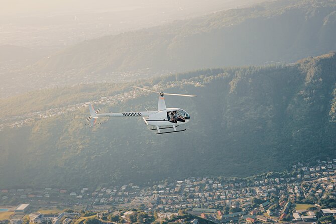
Honolulu from the air feels like a shortcut to awe. This private 30-minute helicopter tour lets you skim above Waikiki’s coast, downtown geometry, and mountain silhouettes in one go, with your pilot pointing out what you’re seeing. I especially like the private group setup, because it keeps the experience focused on your questions and the route.
I also like that you’re not stuck for hours. With a flight time of about 30 minutes, you get a serious bird’s-eye view without treating your day like a full project. One thing to consider: the tour requires good weather, so if conditions aren’t right, plans can shift.
In This Review
- Key things to know before you go
- What a private 30-minute flight over Oahu really gives you
- Price and what $359 covers (and why it can still feel fair)
- Getting ready at the meeting point near 1 Lagoon Dr
- The route: a full highlights tour of Honolulu from HNL
- From Sand Island to Honolulu Harbor
- Ala Moana Beach Park and Magic Island: coastline angles that click
- Ala Wai Harbor and Waikiki: the shoreline you thought you knew
- Diamond Head and Waialae Golf Course: the coast meets the hills
- Honolulu Downtown and Punch Bowl Cemetery: city geometry and a sacred landmark
- H201 Interchange and H3 Highway: the island’s movement system
- Black Point Sea pools and Moanalua Gardens: where you slow your eyes down
- Aloha Stadium: the final landmark before returning to HNL
- How to make the most of a 30-minute window
- Weather, safety, and the one big practical limitation
- Who should book this and who should skip it
- Should you book Honolulu Helicopter Tours for 30 minutes?
- FAQ
- How long is the helicopter tour?
- Where does the tour start and where does it end?
- Is this a private tour?
- What’s included with the flight?
- Do I need a printed ticket?
- Is there a weight limit?
- What happens if the weather is poor?
- What is the cancellation policy?
Key things to know before you go
- Private means just your party: no mixed group seating, so the pilot can work at your pace.
- Phone lanyard is provided: you’ll get a way to keep your phone secure while you look out.
- Aviation headset is included: easier listening to the pilot’s commentary (and less noisy cockpit distractions).
- The route hits a lot of recognizable landmarks: Ala Moana, Waikiki, Diamond Head, Punch Bowl, Black Point, and more.
- 300 lb total weight per passenger: this matters for who can fly.
What a private 30-minute flight over Oahu really gives you
Helicopter time in Honolulu is about perception. From the ground, Waikiki looks like a postcard; from above, you start noticing shapes: the curve of the shoreline, where harbors sit like cutouts, and how streets and ridges line up. In just half an hour, you’ll get a quick “map in your head” for the whole island’s south side.
Price-wise, at $359 per person, this is not a casual add-on. It’s expensive enough that you should book it only if you genuinely want aerial views as the main event, not just a sprinkle of excitement. The value comes from two things you’ll feel immediately: the private format and the included gear that lets you enjoy the flight without scrambling for basics.
You can also read our reviews of more private tours in Oahu


Price and what $359 covers (and why it can still feel fair)
Let’s talk about value in plain terms. You’re paying for a short, high-cost mode of transportation, so the ticket price reflects aircraft time and the pilot’s work. What helps justify it is that you’re getting a dedicated ride for your group plus the basic “comfort and safety” items already included: aviation headsets and a cell phone lanyard.
If you hate paying for “half a thing,” you should know the duration here is tight. This is built for a quick highlights pass, not a long aerial tour. If you’re craving a slower, deeper look, you’d likely want a longer flight option elsewhere—but with this one, the goal is speed and breadth.
Getting ready at the meeting point near 1 Lagoon Dr
Your tour starts and ends back at the meeting point: 1 Lagoon Dr, Honolulu, HI 96819. That round-trip structure is helpful because it reduces “where do we go now?” stress. It also matters for planning your day: you can fit this in without needing half your day for transport and timing buffers.
You’ll use a mobile ticket, so you don’t have to hunt for paper. You’ll also get a provided cell phone lanyard, which is one of those small details that turns into a big sanity saver once you’re in the air and trying to take quick views through the window.
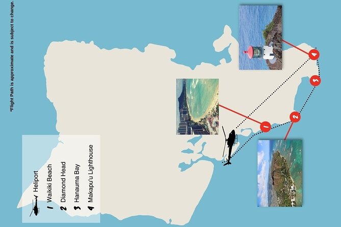
The route: a full highlights tour of Honolulu from HNL
You’ll depart from HNL and come back there, but the sightseeing covers a lot of ground on Oahu’s southern side. Think of it like a loop of famous coastlines and major landmarks, strung together so you can compare how each area looks from above.
From Sand Island to Honolulu Harbor
Right after takeoff, you’ll get views over Sand Island and Honolulu Harbor. These spots help you “orient” fast. From above, harbors stop being vague lines on a map and start looking like working systems: channels, docks, and the way water separates city functions.
A perk here is clarity. Harbor areas can be hard to understand from street level, especially when you’re surrounded by buildings and traffic. From the air, you’ll see the layout immediately, even if you’re not doing any deep sightseeing on the ground.
You can also read our reviews of more tours and experiences in Oahu


Ala Moana Beach Park and Magic Island: coastline angles that click
Next up is Ala Moana Beach Park, followed by Magic Island. This part of the ride is great for reading Honolulu’s coastline. You’ll see how the beach areas and offshore shapes create different “zones” of shoreline—some open and exposed, others more sheltered.
If you like photography, this is a good segment to watch closely. The water-to-city contrast is strong here, which can make Waikiki-era images easier to get right.
Ala Wai Harbor and Waikiki: the shoreline you thought you knew
Then you’ll fly over Ala Wai Harbor and Waikiki. This is the part most people picture before they book. From above, Waikiki becomes a grid of neighborhoods pressed against the ocean, with harbors and beaches acting like anchors.
One practical note: in a short flight, your job is to decide where to look first. If you want Waikiki “glance images,” keep your camera/phone ready during this segment rather than waiting for the next landmark.
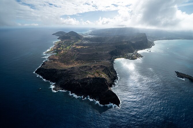
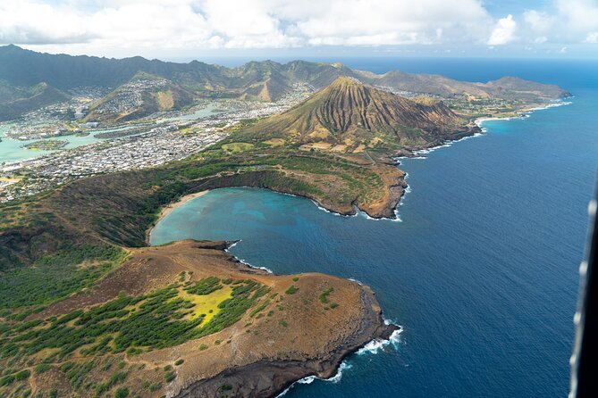
Diamond Head and Waialae Golf Course: the coast meets the hills
As you continue, you’ll see Diamond Head and Waialae Golf Course. Diamond Head is one of those places where aerial views change everything. From the ground, it can look like just a dramatic hill. From above, you’ll understand the shape and how it controls the coastline angles nearby.
The golf course view is also more interesting than it sounds. From the air, you’ll notice how large properties and green spaces break up urban density.
Honolulu Downtown and Punch Bowl Cemetery: city geometry and a sacred landmark
Next comes Honolulu Downtown and Punch Bowl Cemetery. Downtown from above reads like a plan drawing: major roads, blocks, and the way the city spreads outward. Then Punch Bowl shows up as a distinct, memorable form—one of those landmarks that looks like a “feature” rather than a generic dot.
If you like understanding place meaning, this is where the flight gives you context for why the city feels the way it does. You start seeing that Honolulu isn’t just beachfront—it’s also ridges, elevation changes, and big cultural landmarks shaped into the terrain.
H201 Interchange and H3 Highway: the island’s movement system
You’ll also pass over H201 Interchange and H3 Highway. These sections are valuable because they show you the “plumbing” that connects neighborhoods. From the sky, highways stop being just roads and start looking like engineered connections across a complicated physical environment.
Even if you’re not driving much during your trip, this aerial view helps you later when you look at a map. You’ll recognize the routes faster, and that makes planning day trips feel simpler.
Black Point Sea pools and Moanalua Gardens: where you slow your eyes down
Then you’ll fly over Black Point Sea pools and Moanalua Gardens. These are calmer, more nature-leaning views compared with the dense city pockets. Black Point is especially interesting from above because the water features look patterned, almost designed—something you might miss from street level.
Moanalua Gardens gives you a different texture: green space and the way it sits next to developed areas. If you’re trying to understand Oahu’s mix of urban life and nature, these are good “balance points” in the route.
Aloha Stadium: the final landmark before returning to HNL
Finally, you’ll see Aloha Stadium before returning to HNL and ending back at the meeting point. Stadium views can feel like just one more building from above, but here it serves as a solid endpoint. It’s an easy-to-spot anchor that signals the route is wrapping up.
How to make the most of a 30-minute window
Thirty minutes is enough time to cover a lot, but it’s not enough time to “zone out.” Here’s how to get the best experience without rushing yourself.
First, decide what you want most: coastlines, Diamond Head-style highlights, or city structure. The route includes all of those, but you’ll enjoy it more if you’re mentally ready for each segment. Second, use the phone lanyard they provide. You’ll spend less time worrying about holding a phone and more time actually looking out.
Also, choose listening over multitasking. With the aviation headset included, you’ll get more from the pilot’s guidance. There’s even mention of pilot Stefan delivering a first-class, professional flight experience—so if your pilot shares context clearly, lean into it. It turns a simple sight-seeing loop into a “now I understand Honolulu” moment.
Weather, safety, and the one big practical limitation
This experience requires good weather. That’s not a small detail—it’s the main factor that can affect your schedule. If conditions don’t cooperate, you’ll be offered a different date or a full refund.
Then there’s the 300 lb total weight per passenger limit. If you’re near that number, double-check before booking so you’re not stuck dealing with changes later. Finally, the tour is designed for most people to participate, and it’s private, so you won’t be forced into an experience that’s clearly not the right fit for your group.
Who should book this and who should skip it
This tour is a smart choice if:
- you want Honolulu from above as the main event
- you prefer a private experience over sharing the flight time with strangers
- you like seeing multiple famous sites in a short window
- you value included basics like headsets and a phone lanyard
You might skip it if:
- you can’t handle weather-related rescheduling
- you’re hoping for a long, slow aerial tour (this is about highlights in 30 minutes)
- your group wants a lower-cost activity that doesn’t depend on aircraft time
Should you book Honolulu Helicopter Tours for 30 minutes?
If you’re coming to Oahu for the first time and want a fast, high-impact view, I’d strongly consider booking. The route is packed with recognizable landmarks, the flight time is tight and efficient, and the private setup makes it feel like your own experience instead of a slot in someone else’s schedule.
Book it if you’re the type who enjoys “seeing the whole system.” This flight helps you understand Honolulu’s layout in a way a walking tour can’t. Just make sure you’re comfortable with the big reality check: good weather matters, and 30 minutes is short enough that you’ll want to pay attention, not just admire.
FAQ
How long is the helicopter tour?
The tour duration is about 30 minutes. The flight time is also listed as 30 minutes.
Where does the tour start and where does it end?
It starts at 1 Lagoon Dr, Honolulu, HI 96819, USA and ends back at the same meeting point.
Is this a private tour?
Yes. It’s a private tour/activity, so only your group participates.
What’s included with the flight?
The tour includes a cell phone lanyard and aviation headsets.
Do I need a printed ticket?
No. You’ll use a mobile ticket.
Is there a weight limit?
Yes. The total weight per passenger is listed as 300 lbs.
What happens if the weather is poor?
This experience requires good weather. If it’s canceled due to poor weather, you’ll be offered a different date or a full refund.
What is the cancellation policy?
You can cancel for a full refund if you cancel at least 24 hours in advance of the experience start time. Changes made less than 24 hours before the start time are not accepted.